Miles Hiked: 33.5
Last night I woke up around 3am and could see head lamps descending from the South Rim. These were from some runners and hikers doing a double crossing of the canyon and hiking Rim to Rim to Rim in one day. Many of them start in the middle of the night since it’s such a long distance and a lot of vertical to cover as well as trying to avoid the heat of the day at the bottom of the canyon. I was surprised I could see the headlamps from so far away! At 5am I started packing up my things and was walking down the trail by 5:15. I wanted to make it up to the North Rim by noon. The first seven miles of the trail from Bright Angel to Cottonwood Campground ascended very gradually. I’d say that the first four miles felt so flat. Knowing that it was a major ascent from the bottom of the canyon to the North Rim, I was a bit surprised at how flat the first few miles were. In my head I was thinking about how much steeper the last few miles to the North Rim would be because of this. The trail followed bright Angel Creek through a narrow corridor of Canyon walls. A few runners passed by me. I was excited to see them running back down the North Rim. I just think it’s so fun to watch people go after big days in the mountains (a canyon in this case).
Martin Caught up to me right as I made it to the Ribbon Falls sign. We both too the side trail to go see the waterfall but the creek was so swollen and raging that we both turned back around deciding against it. Shortly after that we had to get our feet soaking wet crossing a bit more tame but still gushing creek anyways. I wasn’t expecting to get my feet wet from a water crossing at the bottom of the canyon that’s for sure. We took a break at Cottonwood Campground where I cooked my mystery hiker box oatmeal breakfast that turned out to be very filling. I also filtered a liter for water from the stream so I had 2.5 liters to last me until the top of the North Rim where our last known water source would be. Martin left me here as he wanted to knock out the climb much faster. I can’t say I was as motivated as him. After cottonwood campground is where the trail really started to ascend. I saw even more double crossing hikers and runners around this area. I’m assuming these were the people who started closer to sunrise vs last night. My legs were feeling pretty tired going uphill but if I just kept moving it was easy to forget about. I was really starting to feel the heat of the day as I was going up but when I stopped to take a few short breaks I would be cold from my own sweat soaking my sun hoodie. The trail passed by a water station that was turned off called the PumpHouse, a gushing waterfall known as roaring springs as well as a suspension bridge and a very short tunnel known as Supai Tunnel. As I got closer to the North Rim I could see the snow on the Northern sides of the canyon wall. My last break before reaching the rim was only 0.5 miles away at coconino lookout. I stopped for a picture and took advantage of the cell service for a brief moment receiving some messages but replying to no one. Martin was sitting at the North Kaibab Trailhead waiting for me at the top.
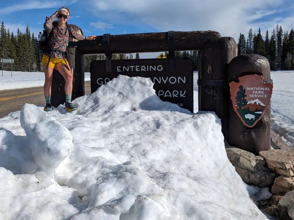
I plopped down next to Martin and started to make my apple crisp desert that I also got from the hiker box as well as drink the remainder of my water. We watched as several groups of double crossing runners made it to the top and all of them kept asking us where the water was even though we hadn’t even bothered to look around for it yet. The spigot at the trailhead was still turned off for the winter but the ranger who issued our permits told us that the water spigot at the backcountry information office had been turned on. Eventually Martin and I made a plan to fill up on five liters of water before beginning our road walk that had absolutely zero water information. I gave Martin one of my reservoirs to borrow as he only had a 2.5 liter capacity for the whole trail so far. I was glad I happened to be carrying an extra one liter water bag with me. We hiked over the snow to the backcountry office post holing here and there until we got to the spigot. There were a few park service vehicles and employees who were getting ready to open the North Rim but not until May 15th. There was a pack scale hanging by the door of the office and I found out that my pack weighed 35lbs with all five liters of water and three days of food loaded up in it. After filling up on water, we set off on the 41 mile road walk to Jacob Lake. The trail was covered in feet of snow and we had no interest in postholing for miles. Not many hikers have finished the AZT ahead of us which is why we don’t have much information on the trail ahead. The two posts I saw on Facebook of those who had finished talked about all the snow and the long road walk. Where the trail crossed the road we could see zero footprints in the snow.
The road walk wasn’t as bad as I thought it would be but it still dragged on. Walking on pavement makes my feet ache way more than a dirt trail does and the extra weight from all the water in my pack wasn’t helping the occasion. Martin and I talked on and off and I listened to podcasts as well. We took our breaks together every 2 hours finding wherever we could sit that wasn’t covered in snow. This usually was in a paved road pull out that had been plowed. After 12 miles of pavement we reached the closed national park entrance and I got a photo by the sign that was covered in snow. The only people we saw on the road walk were park employees who were driving by really fast. When it was getting closer to dark we passed by a closed general store as well as a closed lodge. There was still snow almost everywhere and we had a hard time finding a place to camp. We ended up finding a decent dry spot right next to the road on an elevated berm. The view from camp was pretty great. We could see a wide open snow field as well as sunset on the horizon. The temperature dropped quickly.
Happy Trails!
-Early Bird